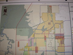
I finally made it over to the City building to take a look at the proposed alignment for North Legacy. What I found was interesting... take a look. You may want to click on over to Flickr in order to view it larger (click on "all sizes" up above the photo).
See the red line on the west? That's the proposed alignment. It runs on 5100 West until north of the Sewer Treatment Facility, then turns slightly east. However, here's where it gets significantly different. the blue road on the north right next to the Box Elder County line is 4000 North. The state's recommended alignment - both option 1 and 2 - cut 3900 West and the corner to travel along 4000 North up to Smith & Edwards and I-15. Plain City's recommended alignment goes west of any existing (on the north end) homes out into Box Elder County - past Willard Bay, I suppose. The map doesn't show how it goes east.
One other item of note. The pink road in the bottom left quadrant of the picture is 2500 North. The pink road doesn't currently exist in its entirety; it ends at 4500 West (where the purple area ends). At one point, the road was planned to extend to a subdivision; now it looks like it will be the connecting road to the North Legacy corridor.
I suggest that you go take a look at the map if you get a chance. It's in the City Council chamber at the City Offices.
Subscribe to:
Post Comments (Atom)


No comments:
Post a Comment